CAROLINAS — Cloudy skies will remain across the region Saturday, but rain chances are becoming much more isolated as the day progresses. Areas including Raleigh, Charlotte, Fayetteville, Wilmington, and Myrtle Beach are expected to see conditions dry out through the afternoon and evening. Rain chances will drop to around 20 to 30 percent for the remainder of the day, with highs generally in the low 80s.
Midday Storms Concentrate Near the Coast and Southeast
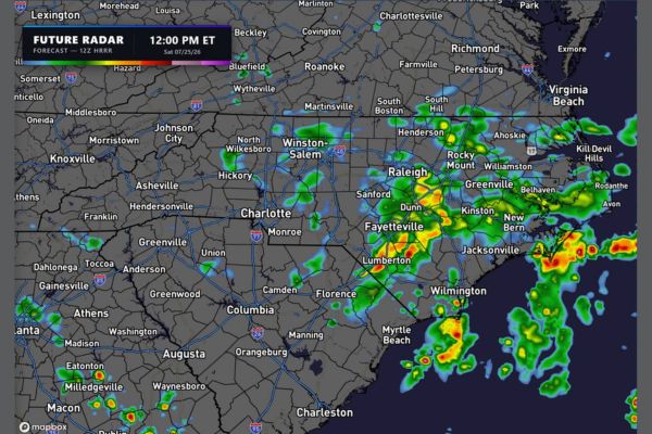
Futurecast radar valid at noon shows scattered showers and storms across the region, with the most notable activity clustered near Fayetteville, Lumberton, and areas stretching toward Wilmington and Myrtle Beach.
Additional coverage was tracking near Raleigh, Kinston, and New Bern at midday, with stronger cells producing heavier rainfall along the coastal corridor extending from Jacksonville toward the Outer Banks region.
Afternoon Coverage Begins Trending Toward Isolated Activity
By 3 p.m., futurecast guidance shows shower and storm coverage beginning to shrink across the Carolinas, with remaining activity concentrated mainly along the coast near Wilmington and Myrtle Beach.
Inland areas including Charlotte, Greensboro, and Raleigh are expected to see drier conditions taking hold earlier in the afternoon, consistent with the broader trend of decreasing rain coverage through the day.
Evening Radar Shows Continued Drying Across Most Areas
The 6 p.m. futurecast frame shows only scattered lingering activity, with the most persistent showers remaining near the immediate coastline south of Wilmington and toward the Myrtle Beach area.
Charlotte, Fayetteville, and Raleigh are expected to remain largely dry through the evening commute, with cloudy skies continuing overhead even as rain chances drop toward the lower end of the 20 to 30 percent range.
Coastal Areas Retain the Best Chance for Lingering Showers
By 9 p.m., futurecast guidance continues to show isolated coverage focused mainly along the coast, particularly near Wilmington, Myrtle Beach, and areas farther south toward Charleston.
Inland communities across the Piedmont and central Carolinas should see mostly dry conditions by this point, with any remaining shower activity staying confined close to the coastline through the overnight hours.
Cloud Cover Persists Even as Rain Chances Diminish
Despite the drying trend, cloudy skies are expected to remain in place across much of the region through the afternoon and evening, keeping temperatures held generally in the low 80s.
Residents across the Carolinas should expect a mostly overcast but progressively drier Saturday, with the best chance for any lingering showers or storms confined to coastal areas as the evening progresses.
Stay with SpeedReadNews.com for the latest weather updates and local forecast coverage.