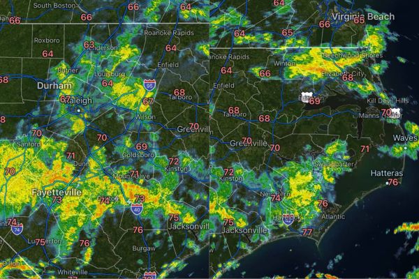
NORTH CAROLINA — Scattered to numerous showers and thunderstorms developed across the state Saturday morning, with radar tracking activity from Durham and Raleigh through Fayetteville, Greenville, and coastal Jacksonville. Some storms are producing heavy rainfall and cloud-to-ground lightning, especially along the coast. Coverage is expected to become more isolated through the afternoon and into the evening as activity shifts west to east.
Morning Storms Bring Heavy Rain and Lightning to Central Counties
As of 9:43 a.m., radar showed widespread shower and thunderstorm activity stretching across central North Carolina, including Durham, Raleigh, Sanford, and Fayetteville. Several cells were producing brief but heavy downpours.
Cloud-to-ground lightning has accompanied the stronger cells moving through the Triangle and Sandhills regions, with additional development noted near Goldsboro, Kinston, and Mount Olive through the morning hours.
Coastal Areas See Heaviest Rainfall and Frequent Lightning
The coast is experiencing some of the heaviest rainfall and most frequent cloud-to-ground lightning with this morning’s activity. Radar highlighted strong returns near Jacksonville, New Bern, and Havelock.
Areas farther east toward Atlantic, Hatteras, and Kill Devil Hills are also seeing shower and storm coverage, with locally heavy downpours possible as cells move through the Outer Banks region.
Charlotte and Piedmont Triad Also Tracking Scattered Activity
Radar shows scattered storms extending into the western Piedmont as well, with activity noted near Charlotte, Concord, and Monroe. Greensboro and the surrounding Triad region are seeing similar scattered coverage.
These storms are expected to follow the same general trend as the rest of the state, with coverage gradually becoming more isolated as the system progresses eastward through the afternoon.
Coverage Expected to Isolate From West to East Through Evening
Forecasters say shower and thunderstorm coverage will continue to narrow through the afternoon and into the evening, with the transition occurring generally from west to east across North Carolina.
Areas that saw storms earlier in the morning, including the Triangle and Sandhills, should see conditions gradually improve first, while eastern and coastal counties may see lingering activity persist longer into the evening.
Warmer and Sunnier Conditions Expected to Return Sunday
A pattern change is expected to bring warmer temperatures and increased sunshine back to North Carolina on Sunday, offering a break from Saturday’s unsettled and showery conditions statewide.
Residents in areas still seeing lightning and heavy downpours Saturday are urged to stay weather aware, especially along the coast where the most persistent activity is expected to linger longest into the evening hours.
Stay with SpeedReadNews.com for the latest weather updates and local forecast coverage.