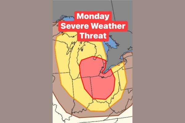
GREAT LAKES REGION — A severe weather threat is developing for Monday across Wisconsin, Illinois, Michigan, Indiana, and Ohio. Forecasters say this system is now officially one to watch for potentially damaging winds. Heat building over the next 48 hours combined with a realigning jet stream will set the stage for explosive thunderstorm development.
Overlapping Ingredients Point Toward Explosive Storm Development
Meteorologists say the atmosphere is coming together in a way that could produce a significant severe weather event Monday. Rising heat and shifting upper-level winds are expected to overlap at the same time.
That combination is expected to come to a head Monday, with explosive thunderstorm development considered likely across the highlighted risk zone stretching from the upper Midwest into the Ohio Valley.
Squall Line Potential Raises Damaging Wind Concerns
Forecasters note it won’t take much of a spark to trigger a chain reaction once storms begin firing Monday. That spark could quickly organize into a squall line capable of producing widespread damaging winds.
There is also potential for multiple squall lines to develop across the threat area, which would increase the risk of damaging wind gusts impacting a broader stretch of the region through the day.
Two Scenarios Still Being Evaluated by Forecasters
Meteorologists say they are watching two possible scenarios play out with this system, though additional data is still needed before determining which outcome is more likely by Monday.
The uncertainty means the exact placement and intensity of the storm threat could shift somewhat over the coming days as forecasters continue refining the outlook heading into early next week.
Highest Threat Area Centers on Illinois and Indiana
The most concentrated risk area on current outlooks centers over Illinois and Indiana, with the broader enhanced risk extending into Wisconsin, Michigan, and Ohio as the system tracks eastward Monday.
Residents across the highlighted zone should stay weather aware heading into Monday, particularly given the potential for a fast-developing squall line capable of producing widespread damaging wind gusts with little advance warning.
Residents Urged to Monitor Forecast Updates Closely
Confidence in explosive thunderstorm development remains higher than confidence in the exact storm mode, meaning residents should prepare for the possibility of significant wind impacts regardless of how the event ultimately organizes.
Officials recommend having a way to receive warnings Monday and reviewing safety plans now, as this system carries the potential for widespread damaging winds across the multi-state threat area.
Stay with SpeedReadNews.com for the latest weather updates and local forecast coverage.