COLORADO — Much of the Front Range and northeastern Colorado are climbing into the upper 90s and lower 100s Saturday. A Heat Advisory is in effect along the I-25 corridor, with additional advisories covering portions of southeast Wyoming and the Nebraska Panhandle. Isolated storms are possible in several zones, though rain coverage will remain spotty across the region.
I-25 Corridor Faces Highs Near 100 With a Late-Day Storm Chance
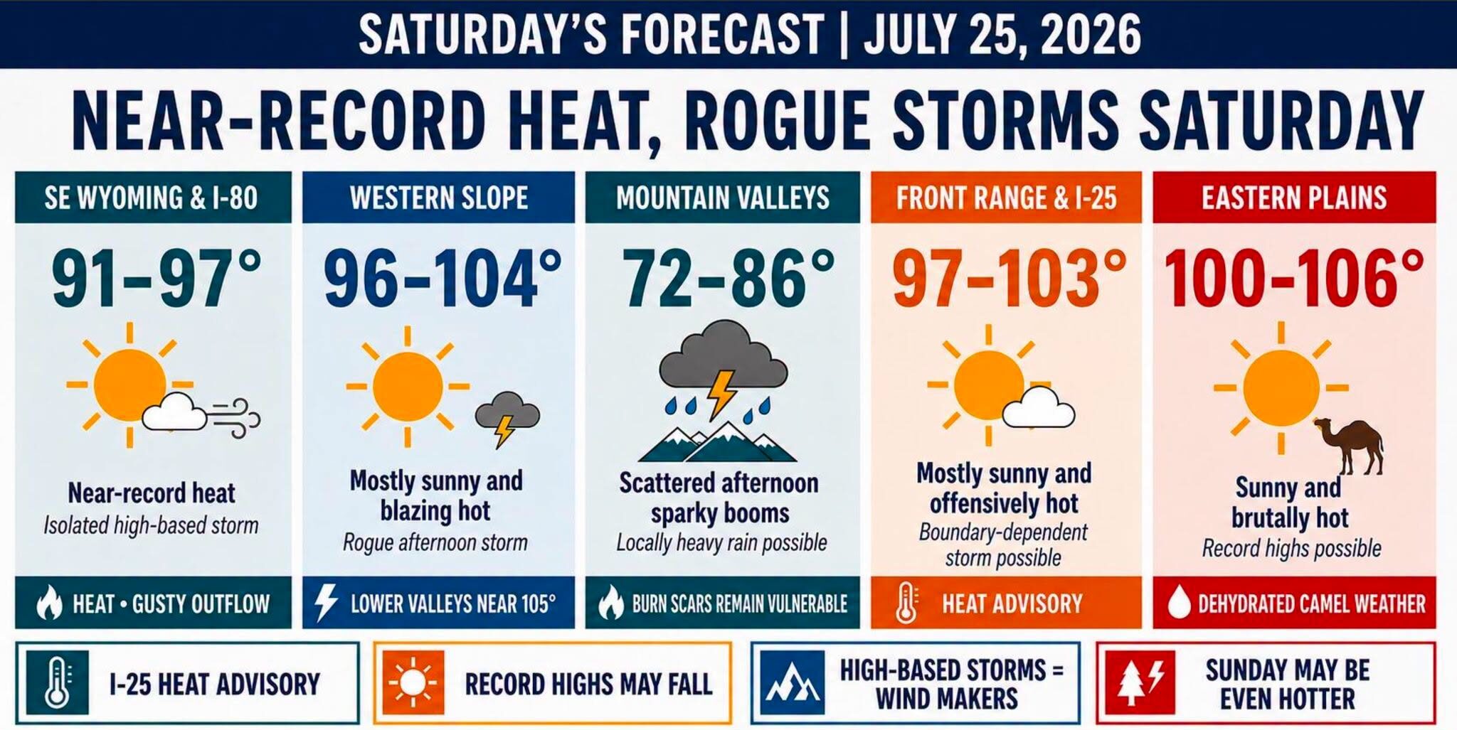
The I-25 corridor is expected to see mostly sunny and offensively hot conditions Saturday, with highs ranging roughly from 97 to 103 degrees. Heat Advisory criteria remain in effect for the entire stretch through the afternoon hours.
A rogue late-day storm is possible, but that potential will largely depend on outflow boundaries drifting off the nearby mountains. Coverage is expected to stay isolated rather than widespread.
Eastern Plains and Nebraska Panhandle Could Approach Daily Records
Widespread triple-digit heat is expected across the eastern plains, western Kansas, and the Nebraska Panhandle Saturday afternoon. Some communities in this stretch may challenge daily temperature records set in previous years.
Portions of the Panhandle could approach highs near 105 degrees, among the hottest readings anywhere in the region. Dry conditions and abundant sunshine will support the sharp afternoon heat buildup.
Mountains and Mountain Valleys Watch for Slow-Moving Storm Impacts
Scattered afternoon storms are expected to return to the mountains and mountain valleys Saturday, with highs generally ranging from 72 to 86 degrees. Storm coverage will be limited but not zero.
Slow-moving storms may bring locally heavy rainfall, raising renewed concern over vulnerable burn scars and steep terrain prone to runoff and flash flooding during heavier downpours.
Southeast Wyoming and I-80 Corridor Eye Near-Record Heat
Southeast Wyoming and the I-80 corridor will see near-record heat Saturday, with highs generally in the 91 to 97 degree range paired with isolated high-based storms during the afternoon.
Rain coverage will remain spotty across this zone, but sudden gusty winds or a dry microburst could develop as the primary hazard rather than heavy rainfall itself.
Heat Trend Continues Into Sunday Before Moisture Returns
Sunday may run another one to three degrees hotter across much of the region before monsoonal moisture makes a more meaningful comeback early next week, offering some relief from the extended heat stretch.
Residents throughout the affected areas are urged to stay hydrated, seek shade during peak afternoon heat, and check on heat-sensitive individuals and animals as dangerously hot conditions persist through the weekend.
Stay with SpeedReadNews.com for the latest weather updates and local forecast coverage.