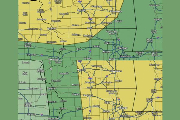
STATELINE REGION — Forecasters are watching a low-end severe weather threat developing for the Sunday night into Monday morning timeframe across the Stateline region, including Rockford, Madison, Janesville, Dubuque, and areas approaching Chicago and Milwaukee. The Storm Prediction Center has outlined the area in a Level 2 out of 5 Slight Risk. Confidence in a widespread severe episode remains low, though forecasters say the setup warrants continued monitoring.
Heat and Humidity Return Sets Stage for Late-Night Storms
The bigger story over the next 24 to 36 hours will be heat and humidity returning to the region in a significant way. With the hot air dome not fully entrenched over the area, the Stateline may sit in something of an atmospheric battle zone.
That setup could allow a complex of stronger storms to move through sometime late Sunday night or very early Monday morning, as warm, humid air clashes with an approaching disturbance from the northwest.
Storm Complex Expected to Fire Near Minnesota and the Dakotas
Current modeling suggests a complex of storms will initially fire well to the northwest, generally near Minnesota and the Dakotas, during the Sunday evening hours before organizing further.
That complex is then expected to dive southeastward toward the Stateline region after midnight, tracking toward areas including Dubuque, Freeport, Rockford, and eventually Chicago and Milwaukee by early Monday.
Storms Likely Weakening on Approach but Gusty Winds Possible
In all likelihood, the approaching storms will be weakening as they reach the Stateline region overnight. However, forecasters note the complex may still carry the potential for producing gusty winds.
Areas along and southeast of the Sunday night risk zone, including Rockford, Beloit, and Elgin, should be prepared for the possibility of wind gusts even as overall storm intensity trends downward.
Confidence in Widespread Severe Weather Remains Low for Now
On a personal concern scale of 1 to 10, forecasters currently rate this setup at about a 2, possibly a 3, reflecting genuine but limited concern heading into the weekend timeframe.
The Slight Risk designation from the Storm Prediction Center reflects a similar low-end outlook, with the Sunday night into Monday morning window carrying the primary window for any storm impacts across the region.
Monday Morning Risk Zone Shifts Toward Chicago and Milwaukee
By Monday morning, the highlighted threat area shifts east and south, placing Rockford, Elgin, Chicago, and Milwaukee within the zone as the weakening storm complex continues its southeastward track.
Residents across the Stateline and northern Illinois are encouraged to stay weather aware overnight Sunday into Monday, with updates expected throughout the weekend as forecasters refine confidence in the setup.
Stay with SpeedReadNews.com for the latest weather updates and local forecast coverage.