ALABAMA — A strong ridge is expected to build in on Monday, though Alabama will remain positioned on the edge of it rather than directly underneath. That positioning has opened the door for an interesting look at model guidance late Saturday night, with the HRRR model showing a plausible wave of storms developing across the state Monday afternoon into the evening hours.
Ridge Position Leaves Alabama Vulnerable to Storm Development
Forecasters say the building ridge Monday will not sit directly over Alabama, leaving the state on the periphery of the stronger high pressure. That edge position is often where storm activity becomes more likely.
Because of this setup, the HRRR model solution showing storm development across the state is considered a plausible outcome, even though confidence in the exact details remains limited more than 24 hours out.
Model Guidance Shows Storms Developing Monday Afternoon
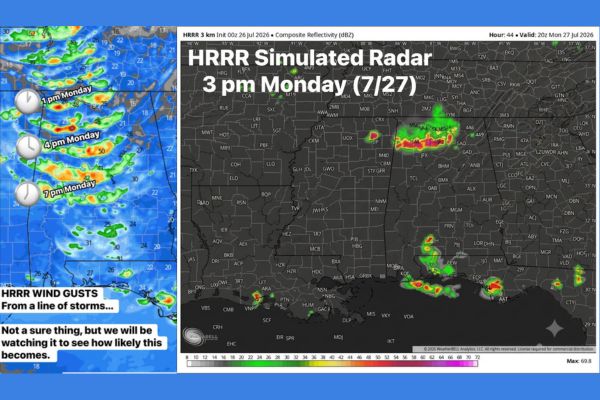
HRRR simulated radar guidance valid for Monday afternoon shows scattered heavier returns developing, with model output highlighting a corridor of stronger cells moving through the region during the 4 p.m. timeframe.
Additional model frames valid around 7 p.m. continue to show shower and storm activity persisting into the evening hours, consistent with the broader afternoon-into-evening timing forecasters are watching for Monday.
Confidence Remains Limited This Far Out From the Event
Forecasters are clear that this scenario is possible but far from a guarantee at this point. Models can offer a useful clue about potential storm development, but they are not reliable for precision this far in advance.
That uncertainty applies especially to timing and placement, with forecasters noting it remains unclear exactly when or where any wave of storms will ultimately develop across the state Monday.
Simulated Radar Shows Broader Regional Storm Activity
The composite reflectivity simulation valid through 8 p.m. Monday shows storm activity extending across a wider swath of the Southeast, with scattered cells tracking through the broader regional area surrounding Alabama.
This broader pattern suggests Alabama’s Monday storm chances are tied to a larger regional weather setup rather than an isolated, localized event confined to just one part of the state.
Forecasters Plan Continued Updates as Confidence Builds
Given the limited lead time and inherent model uncertainty, forecasters say they will continue monitoring the setup closely and provide updates as new model data becomes available closer to Monday.
Residents across Alabama are encouraged to stay weather aware heading into early next week, particularly during the Monday afternoon and evening hours when current guidance suggests the greatest potential for storm development.
Stay with SpeedReadNews.com for the latest weather updates and local forecast coverage.