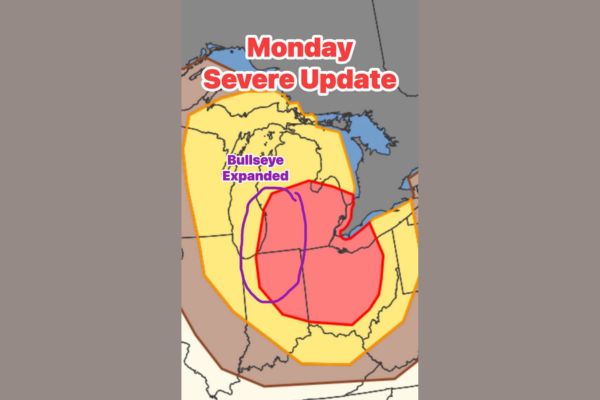
GREAT LAKES REGION — Forecasters have issued a quick update on Monday’s severe storm threat, expanding the bullseye for highest storm chances west into Indiana and Michigan. The elevated risk zone continues to include all of northwest Ohio and southeast Michigan. The expanded outlook aligns with earlier morning discussion of the setup, and there is now some talk of the overall risk level potentially being increased as forecasters continue refining the outlook.
Highest Storm Chance Zone Widens Across the Region
The bullseye representing the highest chances for storms Monday has been expanded westward, now stretching further into Indiana and Michigan beyond its earlier footprint centered closer to Ohio.
This expansion reflects growing confidence among forecasters that the core threat area for Monday’s severe weather event covers a broader stretch of the Great Lakes region than initially outlined.
Northwest Ohio and Southeast Michigan Remain Anchor Points
Despite the westward expansion, the bullseye continues to fully include all of northwest Ohio and southeast Michigan, keeping these areas anchored within the highest risk zone for Monday’s severe weather.
Communities across this corridor should continue monitoring the forecast closely, as this zone has consistently remained part of the most concerning area through multiple rounds of forecaster updates heading into Monday.
Update Builds on Earlier Morning Storm Discussion
Forecasters say the expanded bullseye makes sense given discussion from the morning outlook, which had already flagged the potential for a significant severe weather setup across the broader Great Lakes region.
The consistency between the morning discussion and this updated outlook is helping build forecaster confidence in the overall threat, even as specific details about placement continue to be refined.
Risk Level Increase Under Consideration by Forecasters
There is now some discussion among forecasters about the possibility of increasing the overall risk level for Monday’s event, reflecting the expanding bullseye and growing confidence in a more significant storm threat.
Any change to the risk level would likely affect a broad stretch of the region, given the bullseye now spans from parts of Indiana and Michigan through northwest Ohio and southeast Michigan.
Wider Yellow Zone Still Covers Broader Multi-State Area
Beyond the expanded red bullseye, a broader yellow risk zone continues to extend across a wide multi-state area, including Wisconsin, Illinois, and additional portions of Michigan, Indiana, and Ohio.
Residents throughout this broader zone should stay weather aware heading into Monday, with forecasters expected to provide additional updates as confidence builds regarding the exact placement and intensity of the storm threat.
Stay with SpeedReadNews.com for the latest weather updates and local forecast coverage.