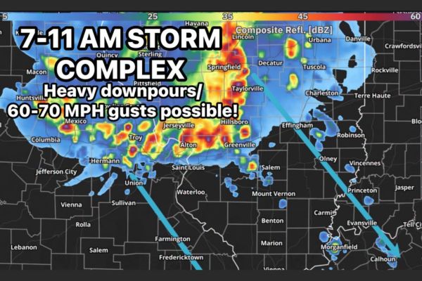
SOUTHERN ILLINOIS — A strong storm complex is possible Sunday morning between 7 and 11 a.m., with guidance suggesting a long-lived system will dive south into southern Illinois. Areas including Springfield, Decatur, Effingham, and Mount Vernon could see the complex arrive between 7 and 9 a.m. before pushing out during the early afternoon. Wind gusts of 60 to 70 mph would be the primary risk if the complex reaches the area, with roughly a 50 percent chance of that occurring.
Long-Lived Complex Tracks South Toward Southern Illinois
Forecast models are suggesting a long-lived complex of storms will dive southward overnight, tracking from areas near Springfield and Decatur toward Effingham, Taylorville, and Hillsboro during the early morning hours.
Forecasters caution that models don’t always handle these types of complexes well, adding a layer of uncertainty to exactly how the system evolves as it moves into southern Illinois Sunday morning.
Arrival Window Targets 7 to 9 AM for Southern Illinois
If the complex holds together, guidance suggests it could reach southern Illinois generally between 7 and 9 a.m. Sunday, impacting communities from Greenville and Vandalia toward Effingham and Olney.
The system would then be expected to push out of the region during the early afternoon hours, with the heaviest downpours and strongest winds concentrated within that morning window.
Damaging Wind Gusts of 60 to 70 MPH Are Primary Concern
The primary risk associated with this complex, should it reach the area, would be damaging wind gusts ranging from 60 to 70 mph, capable of causing tree damage and isolated power outages.
Heavy downpours are also expected to accompany the complex, with radar showing intense reflectivity values already present across parts of Missouri and western Illinois early Sunday morning.
Forecaster Places Confidence at Roughly 50 Percent
Forecasters are placing the odds of this complex actually reaching southern Illinois at about 50 percent, reflecting genuine uncertainty in how the system will evolve overnight before arrival.
That uncertainty stems partly from the inherent difficulty models have in accurately representing long-lived storm complexes, which can strengthen, weaken, or shift track unexpectedly as they travel long distances.
Residents Urged to Stay Weather Aware Sunday Morning
Communities across southern Illinois, including Vincennes, Carmi, and areas near the Indiana border, are encouraged to stay weather aware through the Sunday morning window given the potential for damaging winds.
Residents are advised to have a way to receive warnings during the early morning hours, particularly between 7 and 11 a.m., as forecasters continue monitoring the complex’s track toward the region.
Stay with SpeedReadNews.com for the latest weather updates and local forecast coverage.