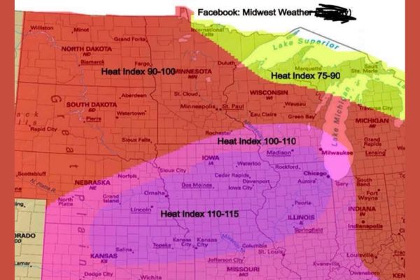
MIDWEST — A corrected forecast map shows Monday’s dangerous heat index will spread much farther north than originally indicated, with values reaching 110 to 115 degrees across a swath stretching from Omaha and Lincoln through Des Moines, Iowa City, Rockford, and Chicago. Forecasters clarified the map represents Monday’s heat index rather than Sunday’s, noting tomorrow will bring far more widespread 100-plus heat index readings farther north than previously shown.
Corrected Map Shows Monday Timing for Extreme Heat
Forecasters issued a correction clarifying that the heat index map circulating actually applies to Monday, not Sunday as originally posted. The distinction matters given how widespread the extreme values will be.
Monday is now expected to bring significantly more widespread 100-plus heat index readings farther north than the original post suggested, expanding the footprint of dangerous heat across a larger portion of the Midwest.
Peak Heat Index Values of 110 to 115 Target Iowa and Illinois
The most extreme heat index values, ranging from 110 to 115 degrees, are forecast across a corridor spanning eastern Nebraska, southern Iowa, and northern Illinois, including Omaha, Des Moines, and Rockford.
Chicago and Aurora also fall within this extreme zone, with the purple-shaded area on the corrected map representing some of the most dangerous heat index conditions anywhere in the country Monday.
Wide Region Sees Heat Index Values of 100 to 110
Surrounding the most extreme purple zone, a broader area including Sioux Falls, Sioux City, Cedar Rapids, Davenport, Peoria, and Springfield is forecast to see heat index values ranging from 100 to 110 degrees.
This zone extends across large portions of South Dakota, Iowa, and Illinois, reflecting a widespread and dangerous heat setup affecting millions of residents across the central Midwest on Monday.
North Dakota and Minnesota See Slightly Lower but Still Elevated Heat
Farther north, areas including Bismarck, Fargo, Minneapolis, and St. Paul are forecast to see heat index values generally ranging from 90 to 100 degrees, still representing a significant and uncomfortable heat burden.
Communities closer to Lake Superior, including Duluth and Marquette, are expected to see comparatively lower heat index values between 75 and 90 degrees, benefiting from the cooling influence of the nearby lake.
Residents Urged to Take Corrected Forecast Seriously
Forecasters apologized for the earlier mapping error but emphasized the corrected outlook now accurately reflects Monday’s true heat threat, which is more expansive than initially communicated to the public.
Residents across the affected zone, particularly in the 110 to 115 degree corridor from Omaha to Chicago, are urged to limit outdoor activity, stay hydrated, and check on vulnerable individuals as dangerous heat builds Monday.
Stay with SpeedReadNews.com for the latest weather updates and local forecast coverage.