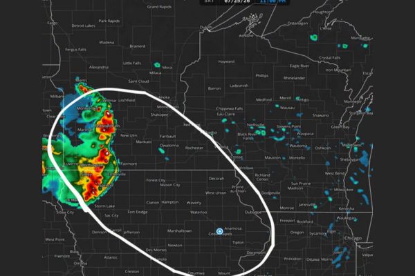
UPPER MIDWEST — A warm front continues pushing northeast as conditions turn extremely favorable for a long-lived storm complex currently organizing in South Dakota. The system is expected to rapidly push southeast into southwest Minnesota and Iowa overnight, with communities including Marshall, Redwood Falls, Worthington, and Spencer positioned within the highlighted threat zone. Damaging wind gusts of 60 to 80 mph are possible within the circled risk area as the complex tracks southeast through the night.
Warm Front Sets Stage for Rapidly Organizing Complex
A warm front pushing northeast across the region is creating extremely favorable conditions for storm development. A complex is currently organizing across South Dakota, with radar showing strong cells already producing heavy returns.
That complex is expected to rapidly intensify as it interacts with the warm front, setting the stage for a long-lived system capable of producing significant wind damage as it tracks southeast overnight.
Complex Expected to Push Into Southwest Minnesota and Iowa
The storm complex is forecast to move rapidly southeast into southwest Minnesota and Iowa overnight, with the highlighted risk zone covering Montevideo, Marshall, Redwood Falls, and areas extending toward Worthington and Spencer.
Communities farther southeast, including Fairmont, Estherville, and Spencer, also fall within the circled threat area as the complex continues its trajectory through the overnight hours into early Monday.
Damaging Wind Gusts of 60 to 80 MPH Are Primary Threat
Within the white-circled area on the current outlook, damaging wind gusts ranging from 60 to 80 mph are considered possible as the complex moves through southwest Minnesota and northwest Iowa.
These wind speeds are capable of producing significant tree damage, structural impacts, and widespread power outages across communities in the path of the strongest cells within the organizing complex.
Forecasters Note Models Struggle With Complex Storm Systems
Forecasters caution that model guidance has historically struggled with accurately depicting long-lived storm complexes like the one currently organizing in South Dakota, adding uncertainty to exact placement and timing overnight.
Despite that modeling challenge, forecasters note the broader atmospheric pattern has consistently favored this type of setup through the current time period, extending into the Monday timeframe as well.
Pattern Remains Favorable for Additional Storm Activity Into Monday
The favorable pattern supporting tonight’s complex is expected to persist into Monday, raising the possibility of additional rounds of strong to severe storms across the Upper Midwest in the coming days.
Residents across southwest Minnesota and northern Iowa are urged to stay weather aware overnight, with a heightened risk for damaging wind gusts as the long-lived complex tracks through the region before daybreak.
Stay with SpeedReadNews.com for the latest weather updates and local forecast coverage.