SEATTLE — A stubborn weather pattern is setting up across the country, and for the Pacific Northwest, it means good news. A big heat dome is reestablishing across the nation’s heartland, with roughly 130 million people under some form of heat alert as of Saturday evening. Seattle, Tacoma, Olympia, and Bellingham, however, are positioned in a steady onshore flow that should bring seasonal, comfortable conditions through the week.
Two Weather Features Sandwich Northwest Into Comfortable Zone
Western Washington and Oregon are caught between the heartland heat dome and a stubborn trough of low pressure stuck in the Gulf of Alaska. That positioning creates a steady westerly onshore flow across the region.
Forecasters say anywhere in western Washington or Oregon is currently a favorable spot to be, as the two larger features effectively cancel out extreme heat and keep conditions relatively mild through the coming week.
Weak Front Brings Limited Rain Chances Sunday
A weak front spinning off the Gulf of Alaska trough will move through Sunday, though most of the associated rain is expected to fall across British Columbia rather than western Washington.
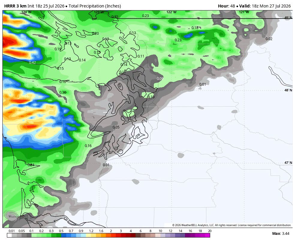
The edge of the front will bring a swath of light rain to the coast and Olympic Peninsula before cutting northeast along the I-5 corridor from about Seattle north, with totals increasing closer to the Canadian border.
Seattle May See Little Rain While Bellingham Fares Better
Precipitation modeling shows Seattle may struggle to pick up much measurable rainfall Sunday, while Bellingham could see around a quarter inch as the front tracks closest to that area.
A sliding scale of lighter totals is expected between the two cities, with Tacoma and Olympia likely seeing minimal rainfall despite the approaching system moving through the broader region Sunday.
Sunshine and Mild Temperatures Define the Week Ahead
A few sprinkles are possible from a weaker second front Tuesday, but the general pattern through next week features brief morning clouds followed by afternoon sunshine and seasonal temperatures.
Highs are expected to range from the mid-70s to low 80s across the Seattle metro area, with the persistent ocean breeze also helping keep smoke out of the region entirely.
Heat Dome Could Shift West Later Next Week
Longer-range guidance suggests the heat dome may begin retrograding west later in the week into next weekend, potentially bringing warmer conditions to the Intermountain West, Desert Southwest, and California.
However, another low pressure system may reestablish near the Gulf of Alaska or off the British Columbia coast, which could act as a buffer keeping Seattle and Portland in the cooler 77 to 82 degree range even the following week.
Stay with SpeedReadNews.com for the latest weather updates and local forecast coverage.